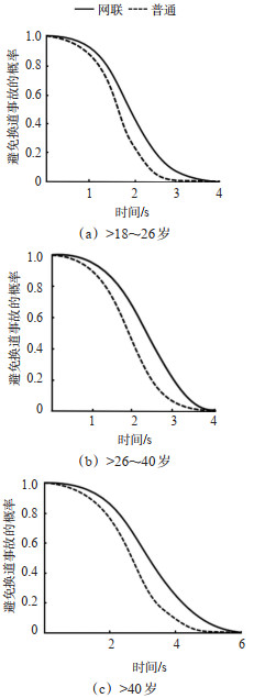
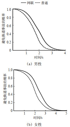
Current Issue

2024, Volume 42,  Issue 2

Display Method:
2024, 42(2): .
Abstract(58) HTML (42) PDF(0)
Abstract:
A Review of Physical Infrastructure Design Methods for Dedicated Lane for Connected and Autonomous Vehicles on Highway
YANG Changjun, ZHENG Chenhao, DAI Jingchen, LI Ruimin
2024, 42(2): 1-11. doi: 10.3963/j.jssn.1674-4861.2024.02.001
Abstract(50) HTML (33) PDF(1)
Abstract:
To thoroughly explore the impacts of the physical infrastructure design of dedicated lanes (DL) for Connected and autonomous vehicle (CAV) on traffic performances, this paper systematically sorted out the ongoing progress in three domains, namely, DL deployment conditions, DL access types, and separation types between DL and general-purpose lanes. It clarifies the theoretical foundations and practical advancements of existing research, constructing a framework that outlines the relationship between physical infrastructure and traffic system performance, and such endeavor has shed light on the research gaps and future direction in this regard. The results indicate that current studies on DL deployment conditions primarily focus on traffic efficiency, while assessments of traffic safety are relatively lacking. Divergent conclusions in existing research stem from different assumptions, thus demanding more precise evaluations of DL deployment conditions in future research. Concerning the access types, both limited access and continuous access have their advantages, yet the embodiment conditions of such advantages require further validation. The design of high occupancy vehicle (HOV) lane access types can also be used for re-evaluation in the scenario of DL. It is essential to ascertain how the separation methods between DL and regular lanes affect the adaptability of human drivers, ensuring their effective adjustment to DL deployment. In general, although some progress has been made in current research, the lack of real-world cases and actual deployment effect verification means that simulation-based methods often yield varying conclusions due to differences in assumptions and other factors. Future research should focus on accurately describing CAV behavior, conducting longitudinal and cross-sectional comparison studies, and quantifying the impact of DL design on safety and efficiency to make improvements.
Time-series Characteristics of Unsafe Events in Air Traffic Based on Visibility Graph
SHI Zongbei, ZHANG Honghai, ZHOU Jinlun, LI Yike
2024, 42(2): 12-24. doi: 10.3963/j.jssn.1674-4861.2024.02.002
Abstract(47) HTML (30) PDF(1)
Abstract:
Time series characteristics of traffic accidents is crucial for understanding air traffic safety. To analyze the characteristics of air-traffic-accident time series, a visual graph (VG) method is proposed. The unsafe-event time series (UETS) are mapped into complex network via the VG, and then the static characteristics of the UETS are described by the topological indicators such as degree distribution and clustering coefficient. Considering the higher-order influences and interaction modes between events, a visual circle ratio index is developed to evaluate the impacts of each event on the entire safety level. A third-order temporal structure representing temporal evolution is proposed based on the sequential model from the VG, describing the dynamic micro- characteristics of the UETS. To demonstrate the proposed method, an empirical analysis is conducted based on 578 unsafe air traffic events that occurred in the United States from 2007 to 2021, and the results indicate that: ① the VG of the UETS exhibit a long-tail degree distribution at both macroscopic and microscopic scales, with clustering coefficients all greater than 0.7; ② the VG network of the UETS possesses small-world characteristics, and the macroscopic sequence-degree distribution follows the power-law distribution with a coefficient of 1.852, indicating scale-free properties of the network; ③ the visibility graphs of different regions also exhibit the characteristics of small-world networks, with significant differences in network size and density among regions, revealing the spatial heterogeneity in the frequency of unsafe events. The visual circle index of the network reaches 33.2%, the circle ratio structural indicator has a significant impact on network robustness, demonstrating that the circle ratio index can be used to identify the effects of different events on the overall safety level. ④ the third-order temporal structure shows significant transition characteristics when the step size is 1 and 2. In summary, this paper reveals that the occurrence of unsafe air traffic events has complex pattern that differs from randomness and periodicity patterns, The safety levels among different regions exhibit spatial heterogeneity and temporal evolution characteristics. Considering the impact of higher-order network structures, managing a minority of nodes with high circle ratios can enhance the overall safety level from a macro perspective. Analyzing the transfer patterns and trend preferences of temporal structures can reveal the intrinsic laws of how air traffic unsafe events evolve over time from a micro perspective. This is conducive to predicting potential risk points, thereby providing a scientific basis for formulating effective preventive measures and safety management decisions.
Complex Network Modeling and the Ephemeral Characteristics of Dynamic Opportunistic Interconnections Among Vessels in Inland Waterway
WANG Yang, CHEN Tao, CHEN Zhiqiang, WU Bing, ZHONG Ming
2024, 42(2): 25-35. doi: 10.3963/j.jssn.1674-4861.2024.02.003
Abstract(53) HTML (34) PDF(2)
Abstract:
This paper empirically studies the opportunistic proximity among inland vessels. A social network analysis (SNA) method considering time-series characteristics is proposed based on the original SNA method, which transforms the network clustering with a large-scale time span into that with a small-scale span and could be used to analyze the dynamic behaviors of inland vessels in limited waters; additionally, considering the temporal characteristics of the proximity relationships among vessels, the complex network theory is employed to model the vessel social network (VSN), which explains the fact that many encountering ships are acquainted with each other in inland region. The AIS data from a 200-kilometer section of the lower Yangtze River in one month are used for demonstration. The results show that: ① the degree distribution of the VSN can be fitted with a Gaussian distribution with a fitting degree of over 96%; ② with the increase of time scale, small-world characteristics and scale-free features of the VSN become apparent, clusters sub-networks consisting of stationary vessels and sailing vessels are observed in the spatial dimension, the density of the VSN slowly increase to 0.1, the average path remains 0.2-0.3, the average weighted clustering coefficient slowly decreases and converges to 0.4-0.5, the dispersion rapidly approaches 1, and overall connectivity is achieved; ③ the average speed of the ships who have high degrees in the VSN with different time spans are highly correlated; ④ with the increase of vessel density, the average neighborhood time in 1 day grows exponentially and the repeated encounters fit a negative exponential distribution. In summary, the establishment or disconnection of data exchange relationships among sailing ships is determined by the ephemeral characteristics of the proximity relationships between vessels in physical space; the interaction behaviors of inland vessels have a memory effect on the interaction behaviors in the future, providing new insights for the research of inland traffic safety.
Characteristics and a Safety Analysis of Driver's Free Lane-changing Behavior in a Virtual Reality-based Connected Environment
QIAN Zehao, PAN Xinfu, FAN Xinwei, YAN Xin, KE Wei, WANG Shunchao
2024, 42(2): 36-48. doi: 10.3963/j.jssn.1674-4861.2024.02.004
Abstract(49) HTML (32) PDF(1)
Abstract:
Traditional driving simulators need help to accurately simulate complex interactions, such as speed variations and lane changes in connected vehicle environments. The connected virtual reality (VR) driving simulator can more realistically replicate vehicle physical characteristics, traffic flow dynamics, and actual road environments using advanced sensors and real-time data processing. A driving simulation system for free lane-changing experiments is developed using traffic simulation and 3D modeling technologies, based on which a scenario library is established and further carry out experiments about free lane-changing behavior. Generalized estimating equations is adopted to establish models of gap selection and lane-changing time. An accelerated failure time model is adopted to analyze the safety impact of the connected environment on free lane-changing behavior. The results can be concluded in two aspects. In connected environments: ① Female drivers exhibit longer lane-changing gaps and need more time. Younger drivers show shorter gaps and need less time. ②An increase of 1 m/s2 in acceleration noise can reduce collision risk by 28% during lane changes, and a 1 m increase in lane-changing gap can increase collision risk by 1.1%.③Older drivers have a higher level of lane-changing safety. Middle-aged and elderly drivers (> 40 years old) show 38.3% and 64.3% higher regarding time-to-collision (TTC) than young (> 27~40 years old) and younger drivers (> 18~27 years old) do. ④Female drivers have a higher level of lane-changing safety than male drivers do, with a 20.1% higher of TTC during free lane-changes. Compared to non-connected environments: ①Drivers in connected environments show a 1.16 m increase in lane-changing gap, a 2.41 s increase in lane-changing time and a 19.72% improvement in the level of safety. ②The probability of occurring lane-changing accidents decreases with the increase of collision risk durations. Specifically, it reduces by 5.8%, 17.2%, 14.4%, and 3.0% at 1, 2, 3, and 4 s of collision risk duration, respectively. These probabilities vary significantly across drivers'genders and ages.
Multi-scale Protected Zone Models and an Improved Velocity Obstacle Method for Aircraft Swarms
AI Yi, YU Yingxue, ZHONG Qingwei, HAN Xun, WAN Qifeng
2024, 42(2): 49-58. doi: 10.3963/j.jssn.1674-4861.2024.02.005
Abstract(52) HTML (37) PDF(0)
Abstract:
The thesis explores aircraft swarming in dense airspace. A multi-scale protected zone model, coupled with an improved velocity obstacle method, is proposed to solve this. Traditional approaches often rely on a single-aircraft protected zone model, which utilizes a velocity obstacle method characterized by complex calculations and suboptimal real-time performance. In contrast, a more advanced approach is introduced, featuring a dynamic ellipsoidal protected zone model and a fusion protected zone model specifically designed for aircraft swarms. These models are crafted to accurately depict the aircraft's flight state and safety intervals. Moreover, the work pioneers the geometric transformation from a single-aircraft protected zone to a swarm-based protected zone. The innovative aircraft swarm protected zone model reduces the dimensional complexity while integrating critical features such as swarm safety intervals and motion characteristics. The paper further develops an improved velocity obstacle method that is grounded on the multi-scale protected zone model. This refined method incorporates a velocity obstacle boundary specifically tailored for aircraft swarms, effectively reducing the computational demands of the algorithm. The proposed models and algorithms successfully portray multiple aircraft as swarms. By establishing boundaries for real-time adjustments in speed and direction specifically for aircraft swarms, they significantly reduce computational complexity. This effectively implements conflict detection and resolution trajectories for aircraft swarms. A comparison of the proposed method with conventional approaches shows a significant improvement in the conflict determination mechanism for aircraft clusters, reducing algorithm computation time by 33%. Additionally, the proposed method leads to a decrease in adjustment amplitude by 60.45%, enhancing its overall performance. The method effectively enhances the efficiency of aircraft conflict detection and resolution under swarming phenomena.
An Evaluation for Impacts of Illuminating Crosswalk Markings on Driving Safety under Low Visibility Conditions
DU Haotian, CHEN Feng, LI Chen, WANG Ruolin, PAN Xiaodong
2024, 42(2): 59-66. doi: 10.3963/j.jssn.1674-4861.2024.02.006
Abstract(48) HTML (33) PDF(1)
Abstract:
Frequent traffic accidents occur at urban pedestrian crossings during nighttime and foggy conditions due to low visibility. Insufficient visibility of traffic facilities and the lack of effective conflict warnings are significant factors. Driving simulation experiments are conducted to explore the effectiveness of new illuminating crosswalk markings compared to regular markings in enhancing drivers'visibility distance and providing traffic conflict warnings. These experiments are based on two low-visibility scenarios: nighttime and foggy conditions, designed using Cinema 4D software. Microscopic individual driving behavior data are collected. The Wilcoxon signed-rank test and Friedman rank sum test are used to deeply analyze the impact of luminescent color, luminescent mode, and luminescent position on drivers'visibility distance and longitudinal speed adjustment behavior. The results show that the drivers'visibility distance with illuminating crosswalk markings is significantly greater than with regular markings in low-visibility scenarios. In nighttime scenarios, the visibility distance with white, yellow, and red illuminating crosswalk markings increased by 36%, 21%, and 54%, respectively. In foggy scenarios, the visibility distance with white, yellow, and red illuminating crosswalk markings increased by 34%, 17%, and 47%, respectively. Besides, the deceleration magnitude of vehicles with white and red illuminating crosswalk markings is significantly greater than with regular markings in low-visibility environments, while the deceleration magnitude with yellow illuminating crosswalk markings is not significant. In nighttime scenarios, the deceleration magnitude of vehicles with white and red illuminating crosswalk markings increased by 101% and 150%, respectively, compared to regular markings. In foggy scenarios, the deceleration magnitude of vehicles with white and red illuminating crosswalk markings increased by 142% and 194%, respectively, compared to regular markings. Moreover, the light source, luminescent form, and color of the illuminating crosswalk markings have a significant interactive effect on drivers' visibility distance. Different combinations of marking attributes significantly impact drivers'visibility distance.
An Improved YOLOv7 Algorithm for Workers Detection in Port Terminals
ZHANG Xiaojie, ZHANG Yanwei, ZOU Ying, YIN Xuecheng, CHENG Qiwen, SHEN Ruchao
2024, 42(2): 67-75. doi: 10.3963/j.jssn.1674-4861.2024.02.007
Abstract(52) HTML (34) PDF(3)
Abstract:
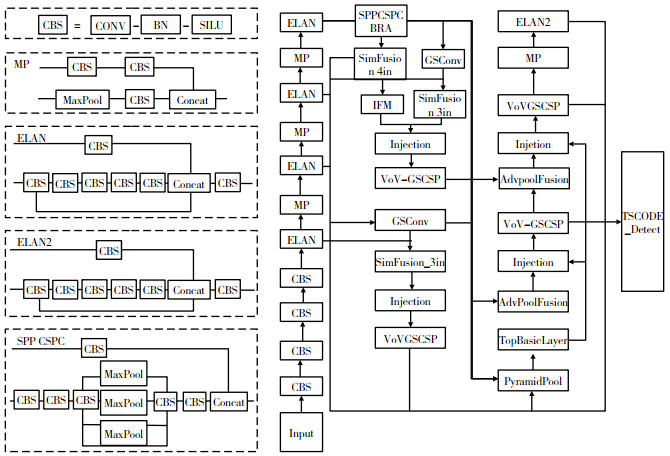
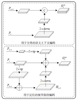
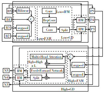
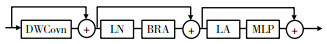
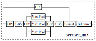
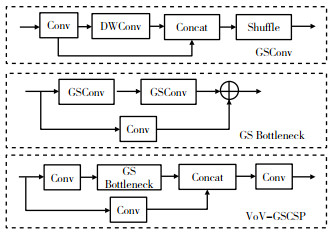
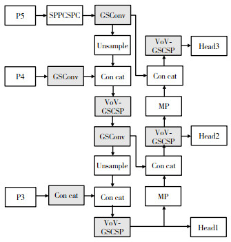
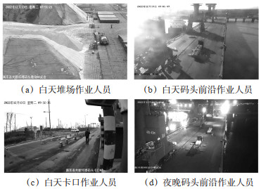
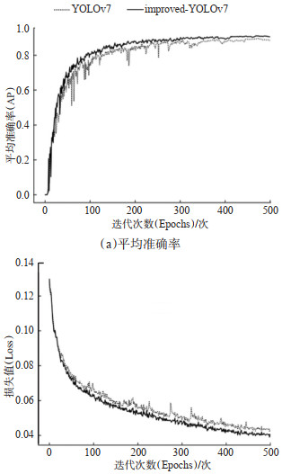
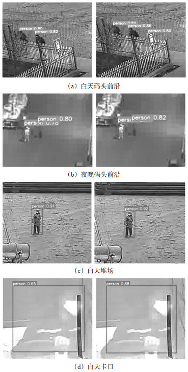
Accurate detection of workers in wide-angle surveillance images is significant for intelligent surveillance in port terminals. However, the traditional YOLOv7 algorithm has limitations on the recognition of workers in wide-angle surveillance images, such as weak feature extraction ability, low detection accuracy, etc. To fill these gaps, an algorithm for terminal worker detection based on improved YOLOv7 is proposed. A task-specific context decoupling (TSCODE) structure balancing the classification and localization tasks is designed, and the gather-and-distribute mechanism (GD) improving the fusion of multi-scale features is applied, which improves the performance and robustness of multiscale features detection from various workers'images. To strengthen the feature extraction of small targets, the vision transformer with bi-level routing attention (BRA-ViT) is introduced into the end of the backbone network, capturing the position, direction, and cross-channel information of small objects. The slim-neck is used to lighten the neck of the network, refine the number of parameters, and reduce computational complexity, enhancing detection speed while maintaining detection accuracy. Fourthly, a loss function with minimum-point-distance-based intersection over union (MPDIoU) is used to calculate the prediction loss of the bounding box, reducing the rates of false negatives and false positives. To validate the proposed algorithm, wide-angle surveillance images in different areas of the port (quay, yard, chokepoint, and other locations) at different times (day and night) are collected and annotated in the dataset, and ablation and comparison experiments are implemented. The results show that the average detection precision (AP) and average detection speed of the proposed algorithm are 90.6% and 39 fps, respectively. Compared with Faster R-CNN, SSD, YOLOv3, YOLOv5, YOLOv7, and YOLOv8, AP of the proposed algorithm is improved by 13.8%, 15.8%, 8.5%, 5.2%, 2.7%, and 3.5%, respectively; FPS of the proposed algorithm is similar to the baseline YOLOv7 algorithm. In summary, the proposed algorithm has higher AP than existing algorithms with responsible detection speed, which is suitable for real-time safety and security surveillance in port terminals.
A Geometric Information Extraction Method of Road Signs in LiDAR Point Cloud Based on RPCA
KE Yunhao, HUANG Yuchun, WU Zijian
2024, 42(2): 76-86. doi: 10.3963/j.jssn.1674-4861.2024.02.008
Abstract(46) HTML (27) PDF(0)
Abstract:
The extraction of geometric parameters of road signs, such as position and sizes, is a crucial aspect of transportation asset management and autonomous driving applications. In vehicular LiDAR point clouds, road signs occupy a small proportion, and are subject to significant interference from surrounding trees, resulting in blurred edges and noise. To accurately extracting the geometric information of road signs, a two-stage pole-like object point cloud segmentation method is proposed. Subsequently, robust principal component analysis (RPCA) is employed to eliminate noise and extraneous points around the signs. The components of independent central poles and sign planes are obtained through the shape analysis of point cloud clusters. Finally, introduce the annular region growth to fit the central poles, and employ normal vector projective sampling and oriented bounding box (OBB) to approxi-mate the signs. Thus, accurate geometric information is obtained for both the central pole and the sign. Experiments are conducted using laser point cloud from 34 different intersections in the Hongshan, Gaoxin, and Wuchang dis-tricts of Wuhan, China. Training and validation using the KPConv segmentation network achieves an accuracy of 90.31%, a precision of 91.07%, and 92.74% recall rate. Additionally, the extraction of geometric information is con-ducted on 98 road signs from 20 intersections within the data above. This method achieves an effective extraction rate of 89.80%, a positional accuracy of 0.062 1 m, and 8.07% geometric error. The experiments demonstrate that this method effectively eliminates noise and extraneous point interference, and performs well on those signs with missing point clouds within 20%.
Improved AIMM-UKF Mobile Target Tracking Algorithm Based on Airport Map Information
CHANG Xin, MA Guanghui, GAO Jianshu, HAO Shiyu
2024, 42(2): 87-94. doi: 10.3963/j.jssn.1674-4861.2024.02.009
Abstract(46) HTML (29) PDF(0)
Abstract:
Given the unique challenges posed by high-density traffic flow and diverse moving targets on airport surfaces, ensuring accurate tracking is essential for effective operation of airport automated equipment such as unmanned vehicles within airports. To address the limitations of the existing Adaptive Interactive Multi-Model-Unscented Kalman Filter algorithm (AIMM-UKF) in tracking moving targets in airport movement areas, an enhanced tracking algorithm is proposed by incorporating high precision airport map information into AIMM-UKF to improve tracking accuracy. Using the detailed airport operating procedures file from the airport map database (AMDB), the construction CAD drawing of an airport is simplified and accurately corrected with ArcGIS software and the second-order polynomial registration method to complete the high-precision airport map correction. The data collected by airport intelligent monitoring equipment is processed in real time, with the coordinate information of moving targets being corrected using the high-precision airport map information. This correction adjusts the observation values in the moving target tracking algorithm. Additionally, by incorporating adaptive correction of the Markov transition probability matrix and applying the observation matrix for secondary correction, tracking accuracy and model matching are improved. Monte Carlo simulation experiments have demonstrate that this improved algorithm utilizes high-precision airport map information to refine the observation values of moving targets. Compared with the Adaptive Correction Markov Transition Probability Matrix Interactive Multiple Model-Unscented Kalman Filter algorithm, this improved algorithm achieves an average reduction of 62.69% in the root mean square error (RMSE) of position and 56.84% in the RMSE of speed. In comparison, this algorithm exhibits superior model matching and superior filtering performance, significantly enhancing the tracking accuracy of moving targets within airport environments.
A Stability Analysis of Mixed Traffic Flows Considering Communication Delay of Connected and Autonomous Vehicles
ZHANG Lu, ZHANG Zhaolei, LIU Zhizhen, TANG Feng
2024, 42(2): 95-104. doi: 10.3963/j.jssn.1674-4861.2024.02.010
Abstract(45) HTML (29) PDF(1)
Abstract:
In traffic systems, minor disturbances can significantly destabilize traffic flow and cause vehicles to exhibit frequent start-stop problem. This study aims to identify disturbance suppression techniques for mixed traffic flows, taking into account the issue of communication delay of connected and autonomous vehicle (CAV). To study the influence mechanism of vehicle communication on the stability of mixed traffic flows, a comprehensive analysis of multiple factors such as the delay of communication among CAV, the market penetration of CAV and the platooning intensity is conducted. Considering the impact of maximum size of CAV platooning, a stability analysis model of mixed traffic flows is constructed based on Markov chain, which can derive the generation probability of different headway types. On such basis, the stability identification formula of mixed traffic flows is developed to analyze the stable speed range under different conditions. In order to improve the efficiency of communication among CAV, the roadside units are used to transmit information. According to the different directions of vehicle-road communication, the communication process is divided into uplink communication from vehicle-to-road and downlink communication from road-to-vehicle. Next, the communication delay estimation model under low traffic density is developed, based on which the communication delay under different CAV penetrations and its platooning intensities to analyze its impact on traffic flow stability. To validate the analytical results, simulation experiments of disturbance evolution are conducted. The results indicate that: ①The market penetration of CAV and its platooning intensity are beneficial to the stability of mixed traffic flow. ② Communication delay has a negative impact on the stability of mix traffic flow. In detail, the delay decreases with the increase of the market penetration of CAV and its platooning intensity, the coverage of roadside units and CAVs'communication radius.③ When the maximum size of CAV platoon equaling 6 and the steady speed of mixed flow travels equaling 25 m/s, only when the market penetration of CAV reaches 60% or its platooning intensity is greater than 0.5, can the delay be less than 0.3 s and the disturbance
Assessing Pavement Rougness Using Jitter Vector from In-vehicle Camera Videos
CHEN Ziang, CHEN Xin, ZENG Yutong, GUO Tangyi
2024, 42(2): 105-114. doi: 10.3963/j.jssn.1674-4861.2024.02.011
Abstract(51) HTML (36) PDF(0)
Abstract:
The process of assessing pavement smoothness is cumbersome, inefficient and time-consuming. To address these issues, a pavement smoothness assessment method based on in-vehicle video jitter vectors is proposed. This method enables preliminary and rapid screening of pavement conditions under normal scenarios. It uses driving videos collected by onboard devices as the assessment data. Preprocessing enhances the contrast of driving video images and reduces the effect of changes in the driving environment on the contrast of video images. The video images then undergo block-wise grayscale projection and similarity determination to remove significant deviations in jitter vectors and interference from moving objects. This extracts the main jitter vectors from the driving videos. The particle swarm optimization (PSO) algorithm improves the search pattern of the projection correlation curve. Using the grayscale projection curve correlation formula as the fitness function in the row (or column) direction enhances search efficiency of the algorithm. A genetic algorithm (GA) optimized K-means clustering algorithm is established to autonomously assess road smoothness at different vehicle speeds by combining vehicle speed and video jitter vectors. Experimental validation shows that the PSO-based grayscale projection algorithm detects smooth road surfaces in 0.148 s, improving efficiency by 91.41% compared to the original algorithm. For rough road surfaces, detection takes 0.123 s, improving efficiency by 87.58%, and consistently detects jitter vector values. The GA-K-means algorithm effectively reduces interference from initial cluster centers, avoiding premature conver-gence.
Segmentation of Overtaking Trajectories for Non-motor Vehicles Based on Information Entropy
ZHANG Rui, WANG Zixuan, KONG Lingzheng, HOU Xianlei
2024, 42(2): 115-123. doi: 10.3963/j.jssn.1674-4861.2024.02.012
Abstract(43) HTML (26) PDF(0)
Abstract:
Identifying overtaking behavior through bicycle trajectories is essential in evaluating the service level of non-motor vehicle transportation. Threshold-based segmentation methods require setting different thresholds for various trajectories, this paper introduces information entropy theory to segment overtaking trajectories of non-motorized vehicle. Using video data, 780 non-motor vehicle overtaking trajectories are extracted, and 11 potential overtaking scenarios are covered. By analyzing the characteristic parameters of each stage of the overtaking process, lateral acceleration, lateral offset distance, and offset angle are identified as the characteristic parameters based on information entropy segmentation. A method for segmenting overtaking trajectory of non-motor vehicles is developed using information entropy theory, and the segmentation judgment criteria is proposed based on this theory. According to the information entropy theory, the law of entropy increase indicates that the probability density of characteristic parameters in two sub-trajectories after segmentation is closer than before segmentation. Besides, considering the features of characteristic parameters of non-motorized vehicle overtaking trajectories, the information entropy segmen-tation standard is proposed for non-motorized vehicle overtaking trajectories. Taking the real trajectory data as experimental samples, trajectory segmentation is carried out using the information entropy segmentation method, and baseline methods with time and speed threshold, respectively. K-nearest neighbor (KNN) classification is adopted for recognizing overtaking trajectories based on the results of trajectory segmentation. Moreover, the trajectory coverage index is used to evaluate the effectiveness of different segmentation methods. The experimental results show that the information entropy based segmentation method has an average coverage of 83.0% for overtaking trajectories, compared to a coverage of 79.7% for the threshold based segmentation method. The information entropy based trajectory segmentation method outperforms the threshold based trajectory segmentation method. Furthermore, the average coverage of lateral acceleration of information entropy based segmentation method is 85.1%, achieving the best performance among the information entropy segmentation methods with different features.
A Scheduling Optimization Method of Shared Bicycles Based on a Multi-objective Ant Colony Algorithm
XUE Qingwan, QU Maiqing, PENG Huaijun, YAO Yunmei, GUO Weiwei, TAN Jiyuan, WANG Yun
2024, 42(2): 124-135. doi: 10.3963/j.jssn.1674-4861.2024.02.013
Abstract(43) HTML (29) PDF(1)
Abstract:
As a crucial mode for facilitating public transportation connections and addressing the "last mile" problem, shared bicycles confront the challenge of supply and demand imbalances. To solve this issue, deploying vehicles for scheduling purposes becomes an essential step in rebalancing the shared bicycles. In order to address the issues of current shared bicycle scheduling methods including single optimization objective, limited visits to scheduling sites, and insufficient consideration of continuous scheduling connections, a multi-objective optimization model is developed in this paper to minimize both total demand dissatisfaction and scheduling costs. This model considers the situation that the demand at the scheduling site surpasses the capacity of the scheduling vehicle during peak hours. Consequently, it enables the scheduling vehicle to make multiple trips to the site and allows to conduct continuous scheduling in multiple periods of time for multiple vehicles. A multi-objective ant colony algorithm is designed to solve this model by integrating the technique of non-dominated sorting to classify the solution set into various levels of non-dominance. The solution at the highest level is then utilized to create a Pareto-optimal solution, which considers two objectives concurrently. This algorithm introduces a new ant system incorporating maximum-minimum criteria, modifies the state transition probability rule and pheromone update rule to enhance their efficacy to deal with the multi-objective optimization problem. In order to verify the feasibility of the model and algorithm, a case study is carried out. The results show that the model is confirmed to be effective in decreasing demand loss while ensuring the lower scheduling costs. Specifically, the total demand dissatisfaction degree is reduced from 26.48% to 17.86%. Comparing the results of the multi-objective ant colony algorithm and greedy algorithm under various example sizes, the multi-objective ant colony algorithm shows a clear superiority in continuous scheduling of multiple periods of time. Specifically, it is capable of organizing the driving path of each scheduling vehicle in each scheduling cycle, as well as the arrival time and the loading and unloading numbers of shared bicycles at each scheduling site. Meanwhile, compared with greedy algorithm, the multi-objective ant colony algorithm shows a clear superiority in the quality of the solutions, and the scheduling costs and total demand dissatisfaction degree obtained in a large-scale case are reduced by 62% and 23%, respectively.
Characteristics and a Simulation Model of Self-organizing Behavior of Pedestrian Flow at Crosswalk under Rainy Condition
YANG Haifei, LU Suqing, LI Yunxuan, CHEN Xian, WANG Liu, GU Le
2024, 42(2): 136-146. doi: 10.3963/j.jssn.1674-4861.2024.02.014
Abstract(50) HTML (34) PDF(2)
Abstract:
To enhance traffic safety and efficiency of urban street-crossing facilities during rainfall, the self-organizing behavior of pedestrian flows crossing streets in the rain is investigated. A corresponding simulation model is also developed. More specifically, the crossing trajectory data of pedestrian flows in both sunny and rainy conditions are collected through on-site observation. Next, a comparative analysis is employed to determine pedestrian flow's distribution of speed, displacement offset for avoidance, and magnitude of spatial overflow with moderate and light rainfalls. Based on these findings, a pedestrian flow movement model for rainy conditions is proposed by modifying the social force model. The model parameters are calibrated and simulation verification is performed using the collected data. The results of the characteristic analysis reveal that: Due to rainfalls, the proportion of pedestrian's speeds ranging between 0.5 and 1.25 m/s increases by 58.80%; while it decreases by 24.37% in the range of 1.25 to 2.0 m/s. This indicates a significant shift of speed towards a lower range (p < 0.001). However, there are 8.05% of the pedestrians, without umbrellas or in an overflow situation, crossing streets at higher speeds in the range of 2.0 to 2.5 m/s. A notable increase (46.8%) in displacement offset is observed when pedestrians encounter each other in rainy conditions, a change that is statistically significant (p < 0.001). The thresholds of the number and flow rate of waiting pedestrians triggering overflow situations decreases by 7 people and 3 people/min, respectively, and the corresponding overflow magnitude ranges from 5.07% to 24.80%. The simulation results indicate that: The proposed model exhibits an accuracy in rainy condition that is comparable to that in sunny conditions. Specifically, the root mean square errors of forward movement in one direction and avoidance movement in opposite directions for sunny conditions are 0.245 and 0.483 respectively, while those for rainy conditions are 0.329 and 0.702 respectively. No significant difference between the simulated speed distribution and the measured one is observed (p =0.620 for sunny conditions, p =0.649 for rainy conditions). The model is able to reproduce the urgent behavior of crossing streets of pedestrians without umbrellas or in an overflow situation. The absolute error of overflow magnitude of pedestrian flows between the simulated and measured situations is 2.08% in typical rainy conditions, while no overflow situations are observed in sunny conditions, which aligns with the empirical findings.
Longitudinal Operational Characteristics of Cars between Small-spacing Interchanges on Freeway
WANG Yanpeng, ZHANG Jie, PAN Cunshu, CHEN Zhenghuan, XU Jin
2024, 42(2): 147-157. doi: 10.3963/j.jssn.1674-4861.2024.02.015
Abstract(47) HTML (35) PDF(2)
Abstract:
To clarify vehicles'characteristics of longitudinal operation between small-spacing interchanges (SSI) on freeways, a field test with 38 subjects is conducted at Baiyanggou Interchange and Paomaping Interchange in the Chongqing section of the G50 Shanghai-Chongqing Freeway. The onboard instruments collected operational data such as speed and longitudinal acceleration under natural-driving state. Then, the speed range, speed bandwidth, and aggregation coefficient are calculated to analyze the constraints of driving behavior and the characteristics of speed change. Finally, the cumulative frequency, probability distribution, and percentile values are investigated after extracting the peak value of each waveform of the longitudinal acceleration curve. The findings are as follows: In the SSI section, the merging and diverging zones tend to overlap, leading to a great degree of vehicle weaving and interference. Consequently, these areas are marked by a more significant difference of vehicle speed and a heightened degree of dispersion. The cross-sectional velocities typically exhibit a skewed distribution, with the speed range in the SSI being greater than that in other sections. Similarly, the longitudinal acceleration generally displays a skewed distribution, wherein the interval of acceleration negative value exceeds that of positive value. Traffic conditions in the SSI are notably complex, necessitating careful maneuver by drivers. Comparing to the normal-spacing interchanges, the average acceleration decreases by 0.28 m/s2 in SSI. In the process of merging, drivers exhibit variability in their preferences for acceleration, with a notable inclination towards higher acceleration positive value (0.542 m/s2) and lower acceleration negative value (-0.081 m/s2). Contrarily, in the process of exiting, drivers demonstrate a certain level of uniformity in their choice of acceleration rates, with minor disparities between the acceleration positive value (0.300 m/s2) and negative value (-0.350 m/s2) rates. Male drivers engage in longitudinal maneuver with a higher frequency than female drivers, albeit at a lower amplitude. Across different driving styles, a certain level of uniformity is observed in the trend of longitudinal acceleration changes.
A Short-term Prediction for OD Passenger Flow in Urban Rail Transit Based on Heterogeneous Data Feature Extraction
CHEN Xiqun, SHEN Loutao, LI Junyi, LI Chuanjia
2024, 42(2): 158-165. doi: 10.3963/j.jssn.1674-4861.2024.02.016
Abstract(42) HTML (25) PDF(2)
Abstract:
As an important basis for rail transit operations and travel choices, prediction for origin-destination (OD) passenger flow in urban rail transit is of great significance in intelligent transportation systems. The conventional convolutional neural network (CNN) mostly focuses on local OD features due to their translation invariance and local sensitivity. To improve its global perception capacity in OD matrix modeling, a heterogeneous data feature extraction machine (HDFEM) model is proposed based on attention mechanism. The model constructs a heterogeneous data OD spatio-temporal tensor and a geographic information tensor from the perspective of spatio-temporal characteristics and land use attributes. It segments and encodes heterogeneous data tensors via a tensor coding layer to obtain the features of tensor blocks in heterogeneous data tensors. Then, it connects the features of each tensor block through the attention mechanism to extract the spatial correlation among various OD matrix parts. This approach not only realizes multi-source heterogeneous data fusion, but also extracts remote features of OD matrix. Meanwhile, the model uses long short-term memory (LSTM) network to deal with the OD temporal feature. Compared with the convolutional neural network-based prediction model, the results on the Hangzhou metro auto fare collection (AFC) dataset show that the mean square error, mean absolute error, and normalized root mean square error of the HDFEM model decreases by 4.1%, 2.5%, and 2%, respectively. The importance of extracting whole spatial features for OD passenger flow prediction of urban rail transit is verified.
A Method for Allocating Bus Passenger Flow by Considering Comprehensive Cost
CHENG Guozhu, LI Weijun, FENG Tianjun
2024, 42(2): 166-174. doi: 10.3963/j.jssn.1674-4861.2024.02.017
Abstract(38) HTML (28) PDF(1)
Abstract:
The inefficiencies and inaccuracies of traditional survey methods for bus passenger flow data need to be addressed. Moreover, bus passenger flow allocation methods are inadequate due to the incomplete consideration of travel cost and significant disparities in travel cost among individuals. Therefore, a study on a bus passenger flow allocation method that considers comprehensive cost is conducted. A mobile signaling data platform based on Data-as-a-Service is developed as a source of data for bus passenger flow allocation. Spatial relationships between users and traffic zones are determined by matching latitude and longitude coordinates. Using a data warehousing tool, data dictionary indexes are filtered to define parameters such as time, speed, and origin-destination types. Transportation modes are identified through time matching and path matching. User proportions are extrapolated to the national population to obtain the bus commuting origin-destination (OD) matrix during the morning peak period for permanent residents. Travel time cost, congestion cost, and fare cost for bus passengers are analyzed. A bus passenger flow allocation model is established based on the principle of maximizing individual benefits while considering comprehensive cost. The problem of bus passenger flow allocation between traffic zones is transformed into a directed weighted graph path selection problem. A hybrid algorithm combining depth-first search and successive averages method is employed to solve this problem, facilitating bus travel plan selection and passenger flow allocation. Taking typical traffic zones in Harbin as a case study, bus passenger flow allocation is conducted and compared with results from the traditional Logit path selection probability model and manual surveys. The results show that the average absolute percentage error between the proposed model and manual surveys is 4%, compared to 17.5% for the Logit model. After allocating passenger flows using the proposed model, the extreme difference, variance, and total sum of individual travel cost are 0.03, 0.000 1, and 1 108.35, respectively, compared to 3.28, 1.58, and 1 127.02 for the Logit model. These results validate the accuracy of the proposed model in allocating passenger flows and highlight the necessity of considering comprehensive cost. After passenger flow allocation, the difference in individual travel cost is smaller, aligning better with the principle of maximizing benefits.